
Debunking the myth: Malta is at no risk from earthquakes. Malta’s seismologists speak up.
A major earthquake hit Malta in 1693. At an estimated magnitude of 7.4, it struck about 170 km away, devastating south-eastern Sicily, destroying buildings and killing almost two thirds of Catania’s population. Historical documents record damage in Malta. Mdina’s cathedral needed to be rebuilt. While some might think that an earthquake of similar intensity is rare and would probably not happen again, research suggests that earthquakes of this strength strike every few hundred years in the area. For many, Malta is considered as an earthquake-free region and even the 1693 earthquake is regarded as a ‘Sicilian’ event.
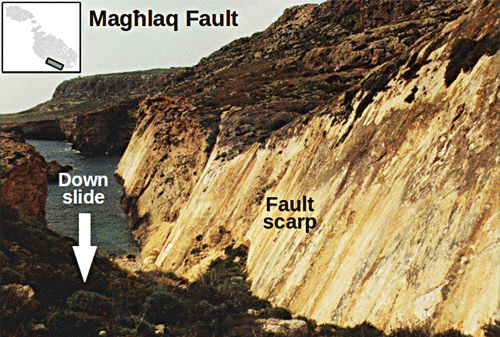
Many of the earthquakes felt in Malta originate beneath Greece, along the Hellenic arc (more than 500 km away), but earthquakes even closer than 50 km away do occur too. Dr Pauline Galea, who lectures at the Department of Physics and coordinates the Seismic Monitoring and Research Unit (SMRU) at the University of Malta, explains that the nearby seismic activity is no surprise. ‘Evidence of major tectonic events that took place millions of years ago is right in front of our eyes.’ The Maltese Islands have been shaped by faulting in which large blocks of the Earth’s crust have been displaced vertically. The seabed of the Sicily Channel (between Sicily and Africa) shows that this is still going on, as revealed by the constant seismic activity being recorded. In the last decade alone over 170 earthquakes have occurred within a 100 km radius around Malta.
To understand the risk of earthquakes to Malta, seismicity close to the Islands needs to be monitored. The SMRU is setting up new facilities to better study these earthquakes. The project is a major investment amounting to €2.5 million, called SIMIT, and funded by the Italia-Malta 2007–2013 Operational Programme. Within this project Dr Matthew Agius, a researcher at the SMRU, is responsible for establishing the Malta Seismic Network and the real-time earthquake monitoring system. Two new, permanent seismic stations are being deployed, one in central Malta and another in Gozo, complementing the seismic station in Wied Dalam. By improving coverage of earthquakes, the new stations will improve the accuracy of earthquake hypocenter location—the point within the Earth where an earthquake rupture starts—and the determination of the fault mechanism. This will provide a better understanding of what is actually causing the local earthquakes to occur.
“When a strong earthquake occurs, an early warning can be activated before the strong seismic waves reach our shores”
Regional earthquakes with epicentres even up to 1,000 km away can also be felt in Malta. These seismic events can pose a danger. In order to monitor these distant earthquakes the SMRU has upgraded its IT systems and installed current state-of-the-art software for early warning systems developed by the seismological community. With this software, ‘virtual networks’ can be created by obtaining real-time feeds from seismic recording stations all over the globe—the size of the network is limited only by the amount of data storage space available. At the moment, data from over 30 stations across the Mediterranean are being retrieved at the SMRU in near-real time. The data is automatically processed to detect earthquakes, and alerts personnel when they happen. The system can issue an alert within a couple of minutes after an earthquake occurs hundreds of kilometres away from Malta. When a strong earthquake occurs, an early warning can be activated before the strong seismic waves reach our shores. Such systems are already in place in countries like Japan, where the early warning system might give just enough time (seconds or minutes) for people to seek a safe place and essential systems, like power stations, to shut down automatically.

Plan, protect, preserve
An earthquake happens because stress accumulates between two sides of a fault line. The locked-in stress gives way suddenly causing a huge quick release of energy that travels through the earth. When a major earthquake strikes an urban area the consequences may be disastrous. The assessment of seismic hazard is one of the most important contributions of seismology to modern society. Seismic hazard refers to the study of the expected earthquake ground motion of a particular area on the Earth’s surface, and the corresponding damage that can be caused there. These studies result in seismic hazard maps that identify the extent to which different areas are expected to shake, on a local, regional, or national basis. Architects and structural engineers need this information to plan for the worst and reduce the risk of damage and death in case a strong earthquake hits Malta.
Recent large and moderate earthquakes worldwide in densely populated areas have shown that buildings are often inadequately built to withstand seismic events. Many houses, industrial complexes, and cultural heritage sites are unable to resist strong ground shaking and may collapse or experience severe damage. To predict how susceptible an area is to earthquake damage, ground motion scenarios (a description of expected ground-motion levels) need to be generated, combined with a probabilistic seismic hazard analysis and proper earthquake source characterisations (an analysis of the size and behaviour of the faults that generate earthquakes). These models simulate how a hypothetical earthquake would affect each point in an area. This is the work of Dr Sebastiano D’Amico, a resident academic at the SMRU. By basing scenarios on realistic earthquake events, such research can help governments understand specific problems based on scientific and engineering knowledge rather than on fear.
D’Amico and other local researchers are building this type of computed scenarios for Malta and nearby regions. These are extremely important. A set of well-crafted scenarios provides a powerful tool for decision makers, emergency planners, private industry, and the general public to evaluate an area’s risk, and create plans that would minimise damage and loss. In addition, the use of these simulations in quasi-real-time can be critical for emergency management that can save lives and optimise Civil Protection operations. Several factors need to be considered to obtain reliable earthquake ground motion scenarios, such as location of the earthquake source, the energy released at the source area, the physical properties of the Earth’s crust, and the local site effects. Over the past few years the SMRU scientists have carried out several studies, investigating the behaviour of different areas of the Maltese Islands during earthquake shaking. This behaviour depends in part on the underlying rock types.

Ph.D. student Daniela Farrugia is helping build a scenario of how the ground surface could respond to earthquake shaking in Malta and Gozo. Using field equipment acquired through the SIMIT project, she is recording and utilising seismic ambient noise—the natural and continuous vibrations of rocks caused by wind, ocean waves, traffic, and other passive sources. This type of commonly available seismic signal is becoming increasingly used by seismologists, who are finding that it can provide detailed information about the Earth. From her analysis Farrugia can establish various rock properties of the shallow subsurface, down to around 100 m in Malta, which affect the amount of vibration and duration of ground shaking caused by an earthquake. Soft layers of rock amplify ground motion and can cause considerable damage even if an earthquake is not large or at distance. The 1985 Michoacán (Mexico) earthquake caused severe damage in Mexico City, which was more than 350 km away, and much less damage in places closer to the epicentre. Mexico City is built on soft shallow sediments.
The Maltese Islands are characterised by four main strata (layers) of sedimentary rocks. The blue clay layer is softer than the other limestone layers, and found commonly in the western half of Malta and Gozo. Farrugia is investigating the degree of amplification caused by the soft clay layer. This information can help create a model that predicts the behaviour of different localities in response to earthquake ground shaking.
Which stands? Which falls?
Violent ground shaking rarely kills people; earthquakes lead to deaths because of collapsing, structurally-weak buildings. In general, damage during an earthquake results from several factors: strength of shaking, duration of shaking, type of soil, and building construction.
During an earthquake all buildings oscillate irrespective of their size. A taller building does not necessarily shake more. This is because different buildings have their own ‘unique’ frequency at which they shake by a much greater amount, known as their natural resonant frequency. Small buildings are more prone to shaking by high frequency waves, whereas high-rise structures are sensitive to slower ground shaking. Moreover, earthquakes from different sources give rise to different ranges of frequency of ground motion. If the frequency at which the earthquake causes the ground to shake is close to a building’s natural frequency, the building is much more likely to be damaged.
“The 1985 earthquake that devastated Mexico City killed 10,000 people, injured 50,000 and left 250,000 homeless”
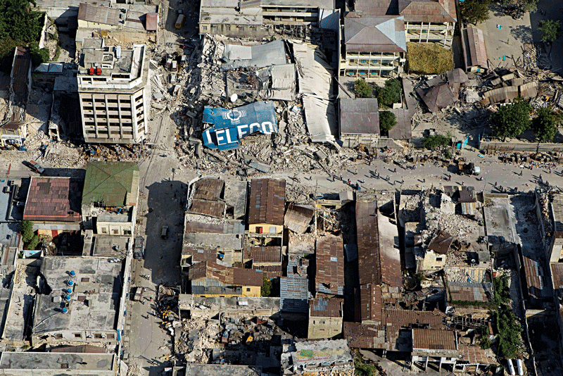
In general the most damaging earthquakes are closer and stronger. The only way to reduce damage is to construct buildings that can withstand the shaking. Sometimes, even weak earthquakes unexpectedly cause a lot of damage because of poor preparedness. In the 1908 Messina earthquake, the major cities of Messina and Reggio Calabria, and surrounding areas, were almost completely destroyed with 70,000 deaths. Buildings were not earthquake resistant having heavy roofs and vulnerable foundations. Four years ago a magnitude 7 earthquake in Haiti caused one of the worst humanitarian disasters in recent history. Again, the buildings that collapsed were built shoddily. Most of the worst natural disasters result from poor strategies in preparing for, and dealing with, earthquakes.
The underlying geology is another key ingredient to earthquake damage. The 1985 earthquake that devastated Mexico City killed 10,000 people, injured 50,000 and left 250,000 homeless. Bizarrely, short and tall buildings remained standing while medium-height buildings proved vulnerable. These buildings’ resonance frequency matched the frequency amplified by the subsoils under this area of Mexico City. The subsoil made the damage much worse than it should have been, leading to a damage bill of $3.5 billion.
Malta needs to learn from these events. In the last few decades urban development has sky rocketed after the nineties’ building and economic boom. If Malta were to be hit by a similar earthquake to the 1693 one, the economic impact and
damage would be very high. All around the world the economic losses from earthquake disasters are increasing, not because earthquakes are stronger or more frequent, but because cities are becoming metropolises having high population densities and sophisticated infrastructures.
The bright side of earthquakes
For many people the word ‘earthquake’ sends shivers down their spine, but for Earth-curious seismologists every earthquake is an opportunity to discover what the Earth looks like from the inside. Just like in the medical field patients undergo ultrasound imaging or CT (computerised tomography) scans to see what is inside their body, similarly, seismologists use seismic waves to image the entire planet.
Earthquakes release tremendous amounts of energy. For each unit increase in magnitude the energy increases by about 30 times. For example, an earthquake of magnitude 3 has the energy equivalent to a large lightning bolt, while a magnitude 6 earthquake has the energy equivalent to the Hiroshima atomic bomb. The 2011 Japan earthquake, which had a magnitude around 9, was equivalent to around 30,000 Hiroshima bombs exploding altogether!
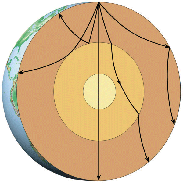
Earthquakes release their energy as seismic waves. The energy radiates across the globe both at the surface and deep within the Earth. These pulses penetrate through the entire planet, literally propagating from one side of the Earth to another—a distance of approximately 12,700 km. In the early 20th century seismologists carried out tedious searches for the arrival of these pulses by examining seismograph recordings from across the world. By analysing this data they realised that the Earth is not a homogeneous sphere of uniform density. Waves were being slowed down, accelerated, reflected, and refracted by the planet’s internal layers. The way the waves are modified gives a clue on the Earth’s rock composition. As a result of these studies, we know that the Earth is made up of a rigid crust, a softer mantle, a liquid outer core, and a solid inner core.
“The 2011 Japan earthquake, which had a magnitude around 9, was equivalent to around 30,000 Hiroshima bombs exploding altogether!”
There are tens of thousands of seismographs around the world keeping track of earthquakes. This number is increasing hand in hand with computing power enabling seismologists to process huge amounts of data relatively quickly, and extract much more detail about the Earth’s interior than ever before. A powerful imaging tool used to image the Earth’s outer layers is the analysis of different velocities of seismic surface waves at different frequencies, an effect known as dispersion. During his Ph.D. at the Dublin Institute for Advanced Studies, Dr Matthew Agius investigated the tectonic dynamics beneath Tibet by studying the dispersive properties of such waves. Tibet is considered a natural laboratory to study active plate tectonics. India is moving northwards towards Eurasia by approximately five centimetres a year and subducting beneath Tibet’s plateau. By analysing how seismic surface waves propagate through the vast region, Dr Agius was able to image the geometry of the Indian continent buried under Tibet, and has established how far north India is beneath Tibet today. Dr Agius explains that when an earthquake strikes it is like a flashlight illuminating the Earth’s interior—the stronger the earthquake the better the quality of the data. The compilation of many earthquake recordings from many seismic stations increases the resolution of the image. Earthquakes give the opportunity to image the world in 3D and help us better understand the driving mechanisms that generate the earthquakes in the first place.

Another study is peering deep into the ground beneath Malta and the Sicily Channel. Mariya Grech Muscat, another research student at SMRU, is studying the seismograms of large, distant earthquakes (more than 1,000 km away), where the waves have travelled through the planet’s interior and were recorded at a few stations in the central Mediterranean. She can extract the part of the signal that represents the last few kilometres of the travelling path of the seismic waves—the layered crust and upper mantle beneath the station. On travelling through these layers the waves are modified and reverberate within the crust. This produces seismic signatures that contain information about the thickness and nature of these crustal layers. In this way the thickness of the crust around Malta and Sicily can be measured. Below the Sicily Channel, a rift in the crust appears to be causing a part of the Pelagian platform to pull away from North Africa (beneath Malta and Tunisia). Such studies could shed more light on what is happening.
Malta is not an earthquake hotspot like California or Mexico, but it is susceptible to large quakes that happen elsewhere in the Mediterranean. The SMRU is finally getting the injection of funds it needs to expand its facilities, work to continue monitoring the local and regional seismicity, and to piecing together the puzzle of Malta’s subsurface landscape. Studies on how different areas of the Maltese Islands could react to earthquakes is important for developing national strategies that will minimise damage. These studies need to go hand in hand with civil engineering efforts to make sure that our buildings are safe. Only then will the Maltese Islands be earthquake ready and ensure the preservation of their beautiful heritage.
This article is part of a series celebrating 100 years since the Faculty of Science was founded on 17 September 1915.
Find the seismologists on the Times of Malta at Quake Watch
Inside our Earth


Comments are closed for this article!