
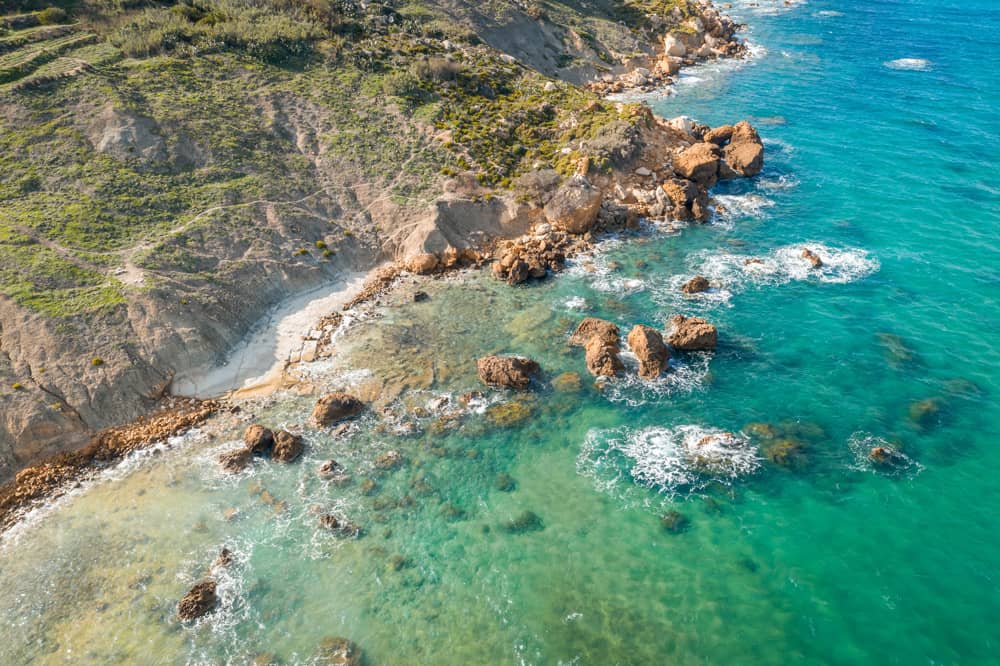
As beaches naturally erode and change, they impact the recreational, economic, and social activities that happen on them. Knowing how, where, and when a beach is being eroded could help us prepare, and this is what the SIPOBED project is about.
Beaches are by no means permanent or constant. They are constantly being eroded, changed, and reformed. This is not ideal for the people and businesses that use beaches, nor for the authorities responsible for the maintenance and conservation of beaches. Beach erosion could damage infrastructure, change the nature and size of beaches, and in the worst case scenario, could result in the disappearance of a beach. Coincidentally, this seems to be the fate of San Blas beach in Gozo. In the last few years, there has been an increase in the frequency of extreme weather events, partly driven by climate change, which could accelerate beach erosion.
Fighting against nature is a losing battle in the long run – and sometimes even in the short run – so trying to counteract the process of erosion is not a plausible strategy. To manage the consequences of beach erosion, stakeholders must prepare. Preparation could mean removing or fortifying infrastructure or closing sections of the beach for bathers. The key to preparation is being informed. This has an added benefit; when developments are planned for beaches, big or small (from installing hand rails to building a new road), we can predict the impact of the development and plan accordingly. Furthermore, studies on beach erosion could reveal cases where human activity has unwittingly contributed to the process.
Measuring Depth…
Beach erosion is caused by the movement of material (such as sand and rocks) from one place to another by the forces of weather and water. Monitoring the process of beach erosion might involve taking multiple measurements over time so that scientists can track how material is moving underwater and where it’s going. As the beach is gradually eroded, several measurements can show some changes. By studying these changes, scientists can estimate the rate of erosion of a certain area. Measuring depth might seem simple enough, but when considering that the measurements must be accurate, precise, and done routinely over large areas – meaning that they need to be cheap and logistically easy – things start to get more complicated.
There are a few traditional methods for evaluating bathymetry (the measurement of the depth of water in oceans, seas, or lakes). One of them is to measure depth by using an echosounder. An echosounder is an instrument attached or deployed from a boat that sends soundwaves into the sea. Some of the soundwaves then bounce from the bottom of the sea and back into the instrument. The echosounder notes the length of time taken for the wave to travel from the instrument to the bottom of the sea and back, and from this, a precise depth measurement is determined. The challenge is that boats usually are not able to access the shallow areas in beaches – which can be vital when trying to measure the rate of erosion. Additionally, carrying out an echosounder survey can be expensive and involves complicated operation. Lidar (light detection and ranging) is another instrument used for depth measurements. Instead of soundwaves, lidar uses a pulsed laser to generate precise measurements. Although most lidar instruments are air-borne and can take measurements of a whole bay, including the shallow areas and the above-water topography, it presents the same challenges as the echosounder: it is expensive, time-consuming, and a logistical challenge. Furthermore, lidar is only feasible for relatively shallow and clear waters.
…Using Satellites
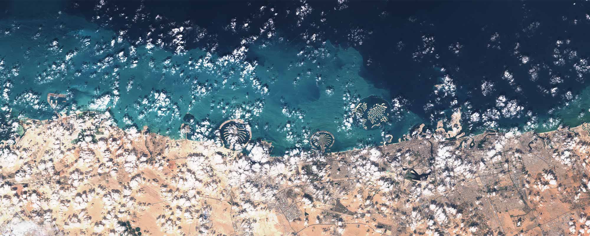
The answer might seem surprising, but one way to efficiently get extensive and accurate measurements of the depth of the seafloor in shallow water is by observing it from space. Satellites orbiting the earth, such as the Sentinel-1 and Sentinel-2 satellites, have been taking high-quality images of the earth for years. Better still, this treasure trove of data is publicly available, and Prof. Sebastiano D’Amico and his colleagues in the Department of Geosciences at UM are making good use of it. Through the SIPOBED (Satellite Investigation to study POcket BEach Dynamics) project, scientists have been processing satellite images with artificial intelligence algorithms to obtain water depth measurements in pocket beaches around Malta.
First of all, a pocket beach is a sandy beach confined between two headlands. The word ‘pocket’ refers to the geological formation rather than the size. In pocket beaches, sediment tends to stay between the headlands, and the SIPIOBED project aims to track the course of the sediment as it moves from one part of the bay to another. D’Amico and the rest of the team have analysed satellite images and then ground-truthed them. In other words, they have compared their measurements from the satellite images with measurements from the more traditional lidar method. The ground-truthing confirmed that the depth measurements obtained from the satellite images are quite accurate.
The seabed and the topography of pocket beaches all over Malta were surveyed up to the dune system. Consequently scientists can now track how the shorelines move back and forth and find out how this movement might be driven by winds and by wave direction. This information can help authorities responsible for risk management when making decisions both big and small, such as where to put deck-chairs or new infrastructure. The end product of the SIPOBED project will be a geographic information system (GIS) tool that will be freely available to any stakeholder. There are multiple and sometimes conflicting uses and demands of beaches in Malta, which include sport and recreation, the conservation of fragile ecosystems, tourism and commerce, and the preservation of cultural heritage and monuments. The information on beach dynamics that will be made available in the GIS tool could potentially guide stake-holders to take the best long-term decisions.
Beaches in Malta are unique due to their small size. There is not much possibility of comparing geological processes and management strategies with other Mediterranean beaches due to this uniqueness. That is why local research that addresses specific local needs is important, as it provides a direct and practical service to the people and organisations that need it.
This research was supported by the project Satellite Investigation to study Pocket BEach Dynamics (SIPOBED, SRF-2021-2S1, PI: Sebastiano D’Amico), financed by the Malta Council for Science and Technology (MCST, https://mcst.gov.mt/) through the Space Research Fund (building capacity in the downstream Earth Observation Sector) a programme supported by the European Space Agency.


Comments are closed for this article!