
Many would say that Malta’s rich history is evident for all to see. From Mdina to Mnajdra, much of the island’s past is present and tangible in our everyday lives. But what heritage is still hidden? Dr Timmy Gambin writes about the efforts made to bring to light the history beneath the waves.

For a nation with a surface area of 360km2, Malta has a disproportionately large concentration of heritage sites. Occupation and probable continuous habitation over the past 7,500 years have left an indelible mark on our landscape. Unsurprisingly, much of Malta’s history is inextricably connected to the sea—a link manifested in the unique harbor structures, our art and folklore.
It can be hard to imagine how much of Maltese maritime history is actually on the seabed. Hard because when one looks out to sea, all that is visible is a vast blue—a surface impenetrable to most. Indeed, even standard SCUBA divers do not quite comprehend the potential for underwater cultural heritage that lies in waters beyond the 50m contour. Another reality many are not aware of is the sheer vastness of seabed for which Malta is responsible. Within its 12 nautical mile territorial waters, Malta has over 3,000km2 of seafloor—nearly 10 times the land area. Although one cannot expect to have similar concentrations of cultural heritage on the seabed as are present on land—the potential is huge. To better understand our underwater cultural heritage, it was deemed essential to explore the seabed around the Maltese islands. The guiding principle behind this initiative is: ‘to manage, one needs to know’. But where does one begin?
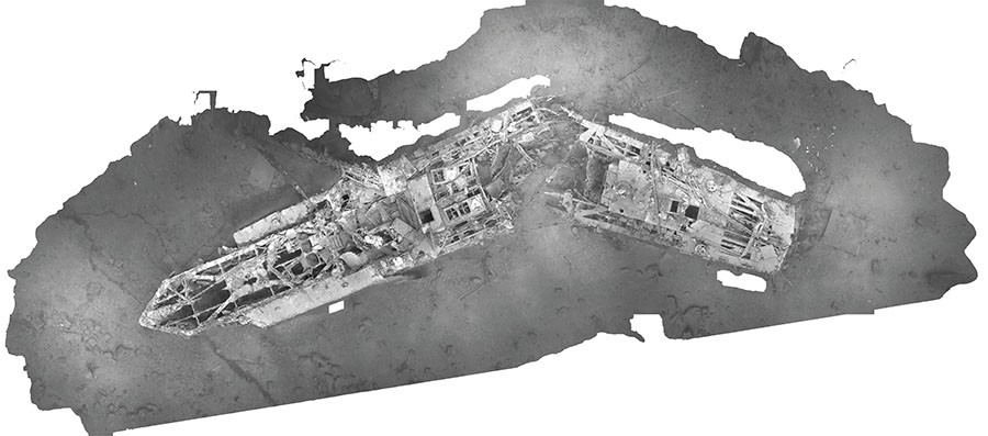
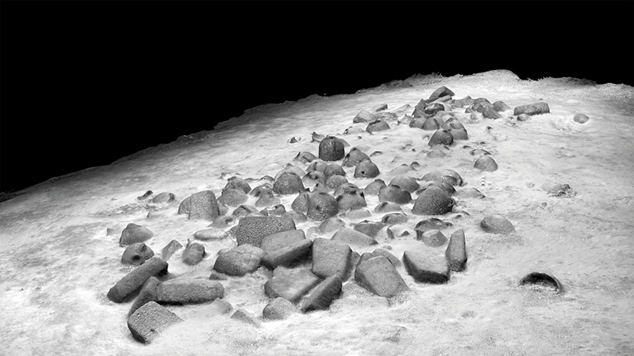
It is only once this information is in hand that decisions and plans can be made to proceed with the second M: management. The plan’s next steps are dictated by the targets present in the area of study and the resources available. What is crucial at this stage is the identification of the target, its typology, and its state of preservation. On the basis of this information, it will be far easier to decide on the level of attention to dedicate to each site. Another factor considered is that of threat. Threats can stem from activities such as fishing, ship anchors, looting, or even damage through natural processes. Once these aspects are determined, we then proceed with further in-depth studies. Such studies include visual inspections, further recording through photography and video, as well as very high-resolution 3D modelling. These help build a comprehensive picture of the site.We developed a 3M approach which is currently being implemented to break down what may seem to be an overwhelming task. The first stage, or M, of this long-term strategy, is mapping the seabed. With the support of the Planning Authority, the University of Malta (UoM) has been systematically surveying the seabed using a side scan sonar system. The system (owned and deployed by the UoM) is towed, but for the past three seasons, we have had the use of an Automated Underwater vehicle (AUV). The latter is extremely time-efficient, especially in deep waters. What we set out to do, year after year is map an area of seabed that was previously unexplored. We ‘fly’ the sonar along a regular pattern that is predetermined using specialised planning software. Each survey block consists of about 25km2, taking between two and five days to complete. This variation is determined by a number of factors, including whether a towed system is deployed or whether we run a survey using an AUV. Once collected, sonar data are stitched using specialised software that produces geo-referenced images of the seabed. In-depth inspection of these datasets permits us to identify interesting anomalies (or targets) and prepare these as lists.
The ultimate aim is for Malta’s underwater cultural heritage to be elevated in status and to match the importance of land sites.
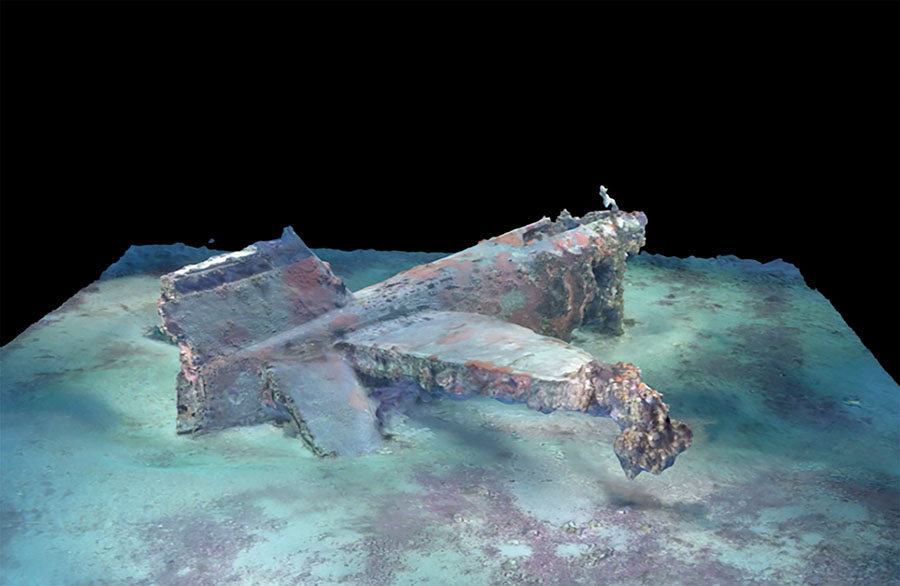
Since June 2015 we have collaborated with colleagues from Finland and have developed a low-cost 3D modelling process that is very cost effective. Using 4K video footage, thousands of photographs are subsequently used to create an accurate and scaled 3D model. These models provide yardsticks for the determination of site preservation as well as for the colonisation of these archaeological sites by marine life. Furthermore, periodic visits to these sites enable us to monitor the site formation processes. The third and final M is monitoring. We are now working in close collaboration with various entities, both locally and overseas, to develop methods and tools for the monitoring of Malta’s underwater cultural heritage. One system being explored is the use of European satellites to act as a sentinel for any illicit activity.
Many of Malta’s submerged cultural assets remain undetected on the seabed. However, large stretches of seabed have already been mapped with numerous sites currently being investigated. The ultimate aim is for Malta’s underwater cultural heritage to be elevated in status and to match the importance of land sites. The sea has many stories to tell, and we are working hard to share them.


Comments are closed for this article!